Skip to content
added to favourites
removed from favourites
Oops! Something went wrong. Try again
Your account is being created
Your account has been successfully created and you are now logged in
You are logged out.

How best do I reach the Würzjoch pass?

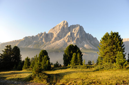
The Würzjoch pass (1,982  m.a.s.l. - Ladin: Ju de Börz, Italian: Passo delle Erbe) is situated at the foot of the Peitlerkofel mountain and connects the Ladin Val Badia valley with Lüsen/Luson, Villnöss/Funes and Brixen/Bressanone in the Eisacktal valley. It  is a popular destination for those  keen to experience the unique landscape of the UNESCO World Heritage Dolomites. The  best way is without a car: that’s because on foot, by bike, via the cable car or public transport, you can conquer the passes in a sustainable manner whilst enjoying the  superlative backdrop  of the Dolomites

Reaching the Würzjoch pass on foot

One foot after the other is the best way to reach the pass. In addition to sporting activities in the breathtaking landscape of the Dolomites, hikers can also experience the  flora and fauna  of this fascinating mountain world up close and personal.

Tip: Before setting off, inform yourself about safety in the mountains, the current weather conditions and whether the hiking trail of your choice is open.

Antermëia/Antermoia (San Martin de Tor/San Martino in Badia):
From the Antermoia craftsmanship zone
:
Duration: 1:45 h, altitude difference: 500 m ↑, length: 4 km
From the craftsmanship zone in Antermoia, follow trail no. 1 B and the markings to the Pè de Börz car park. Turn left behind the barrier, then continue on hiking trail no. 1.

From the valley station of the Antermoia ski lift:
Duration: 1:30 h, altitude difference: 480 m ↑, length: 4 km
From the valley station of the Antermoia ski lift, follow the side road, hiking trail no. 8, to Fornela and the Würzjoch pass.

From Lungiarü/Longiarù:
Duration 3:30 h, altitude difference: 800 m ↑, 220 m ↓,  Length 9.7 km
From Lungiarü, follow the road to the hamlet of Vi, then continue on hiking trail no. 9 to Göma, hike the Peitlerkofel mountain circular trail no. 8 B to Munt de Fornela and then descend on trail no. 8 A to the Würzjoch pass.

Villnöss/Funes:
From the Zanseralm mountain hut (end of the valley):
Duration: 5 h, altitude difference: 824 m ↑, length: 13.9 km
From Zanseralm follow trail no. 32 to Schlüterhütte, then follow hiking trail no. 35 to Gömajch pass and trail no. 8 B to the Würzjoch pass.

From Russis:
Duration: 2:50 h, altitude difference: 500 m ↑, length: 8 km
From Russis, hike along the lower Günther-Messner trail to Gunggan and then along trail marker no. 8 A to the Würzjoch pass.

From St. Magdalena/Santa Maddalena:
Duration: 5:10 h, altitude difference: 900 m ↑, length: 14.9 km
From St. Magdalena, follow trail no. 32 to the Kaserboden area and trail no. 11 to Halsl, then continue along trails no. 4 and no. 8 A to the Würzjoch pass.

Lüsen/Luson:
From the Oberflitt car park:

Duration 4:30 h, altitude difference: 601 m ↑, 352 m ↓, length: 13 km
From the Oberflitt car park, hiking trail no. 10 - 1 leads to the Glittner Ställe mountain hut, from there follow the DOLORAMA long-distance hiking trail via the Lüsner Joch and the Maurerberg Hütte mountain hut to the Würzjoch pass.

From the Stadl car park:
Duration: 2 h, altitude difference: 470 m ↑, length: 5 km
From the Stadl car park, head via the Schwarzbachtal valley on the hiking trails no. 7, no. 7A and no. 1 to the Würzjoch pass.

From the Kalkofen car park:
Duration: 1 h, altitude difference: 290 m ↑, length: 3 km
From the Kalkofen car park, reach the Würzjoch pass via hiking trail no. 1 and no. 8.

From the car park of the Plose cable car:
Duration: 3:40 h, altitude difference: 395 m ↑, 463 m ↓, length: 11.3 km
The Plose cable car goes to the Kreuztal mountain station. Head via the first section of the Woody Walk hiking trail and continue via hiking trailno. 17 C to the ski hut. From the ski hut, head via Alpine trial no. 8 to the Schatzerhütte mountain hut. After the Schatzerhütte, continue via trail no. 4 to the Halslhütte mountain hut, then head via trail no. 8 to the Würzjoch pass.
Alternatively, take bus line no. 321 to the ski hut. The hike can also be started (duration: 1:45 h) from here.

From Brixen/Bressanone:
Duration: 4:10 h, altitude difference: 571 m ↑, 625 m ↓, length: 13.3 km
From the Brixen, take bus line no. 321 to the valley station of the Plose cable car then continue with the cable car to the Kreuztal mountain station. Then take Alpine trial no. 14, past the Rossalm Alpine hut and the Hintere Alm and Wackerer Alm private Alpine pastures. From there, follow trail no. 9, cross the Lüsner Bach stream (Lasanke) and hike along hiking trailno. 8 to the Würzjoch pass.

Tickets for the cable cars and lifts can be purchased directly on site or at the Tourist Info, and the bus ticket directly on the bus. With the BrixenCard and DolomitiMobil Card  guest cards , ride on the Plose cable car and enjoy free-of-charge public transport. Other guest cards cannot be used for the lift. Dogs may be transported free of charge on the Plose cable car (with muzzle). 

The most scenic hikes at the Würzjoch pass

Around the Würzjoch pass, hike to the Lüsner Alm Alpine pasture or in the Puez-Geisler Nature Park on easy-to-walk  hiking trails, some of which are buggy-friendly, as well as on more challenging routes. Either way, magnificent panoramic views of the Peitlerkofel mountain and the surrounding Dolomite massifs are guaranteed!

Reaching the Würzjoch pass by bike

Easily reach the Würzjoch pass via racing bike, mountain bike or e-bike. We recommend finding out in advance if the route of your choice is open in addition to the current weather. Also, please obey fair and safe cycling practices. 
According to the local road code, the pass is passable via bike without restrictions. From Villnöss/Funes and the Val Badia valley (S.Martin de Tor/S.Martino in Badia) via the SP29 provincial road and from Lüsen/Luson via the SP30 and SP29 provincial roads.

  • Please note: It is not possible to take bicycles on public transport around the Dolomite passes.

Well equipped & fully charged

To make sure that nothing gets in the way of your cycling experience around the Würzjoch pass, there are numerous bike rental shops and e-bike charging stations nearby.

Unfortunately we could not find any result

Brixen-Plose-Würzjoch Tour:
Duration: 2:20 h (mountain biking), altitude difference: 569 m ↑, 614 m ↓, length: 19.9 km
From Brixen/Bressanone, head via the SP29 provincial road to the Plose cable car. Then head to the Kreuztal mountain station with the Plose cable car. Depending on your level of skill as biker, then head via one of the trails to the Brixen Bikepark. Take either the Jerry Line (beginners), Hammer Line (advanced) or Palm Pro Line (experts) to Palmschoss. Continue along the SP29 and past the Halslhütte mountain hut to the Würzjoch pass. Alternatively, take bus line no. 321 from Brixen/Bressanone to the Plose cable car valley station. 

With the BrixenCard and DolomitiMobil Card guest cards , ride on the Plose cable car and enjoy free-of-charge public transport. 

Arriving to the Würzjoch by bus

Using the Mobilcard or the regional Guest Cards (e.g. Brixencard, DolomitiMobil Card, HolidayPass, KlausenCard), guests can travel by bus free of charge (validation required at the beginning of each journey). Alternatively, tickets can be purchased directly on the bus. Children younger than 6 do not need a ticket.  Dogs must be kept on a leash and muzzled if necessary. Small dogs travel free of charge. 

From Villnöss/Funes:
From Villnöss, you can reach the Würzjoch pass with  bus line no. 339 (St. Peter/San Pietro - Villnöss – Würzjoch pass) from May to November. Due to the narrow pass road, only minibuses operate on this route. The bus line usually starts from St. Peter (Villnöss), or, alternatively, as a connection to the bus lines no. 330 from Brixen/Bressanone and no. 331 from Klausen/Chiusa. 

From San Martin de Tor/San Martino in Badia - Val Badia valley:
The Würzjoch pass can be reached from mid June to the beginning of October by taking bus line no. 464  (Antermëia/Antermoia/Val Badia - Würzjoch pass) every hour. Bus line no. 464 runs from the Pikolein cable car (as connection to bus line no. 460 from Bruneck/Brunico - Corvara) to the Würzjoch pass.
From the beginning of September, passengers will have to change to bus line no. 339 in Antermoia .  

From Brixen/Bressanone:
From Brixen, reach St. Peter (Villnöss) with  bus line no. 330 . From there, change to minibus line no. 339 to the Würzjoch pass.

From Lüsen/Luson:
From mid-June to October, a a hiking shuttle service runs to the Würzjoch pass every Monday and Friday. Holders of the LüsenCard guest card can use the hiking bus to the Würzjoch pass free of charge. All other passengers over the age of 14 pay 2€/single journey

Reaching the Würzjoch pass by private vehicle

Although it is permitted to drive to the Würzjoch pass in summer by private vehicle we advise against it due to road congestion and for reasons of sustainability. Parking at the Würzjoch pass is limited. Parking on the side of the road is sanctioned by law enforcement officers according to the road code.
PLEASE NOTE: The pass road to the Würzjoch pass (SP29) is in some sections a very narrow and a single-lane mountain road, especially in the Villnöss-Würzjoch area. In addition, traffic jams and other inconveniences can be expected at any time during the summer months. For the current traffic situation or possible pass closures, we recommend consulting the traffic information centre.  

In South Tyrol, sustainable transportation is a top priority. For this reason, it is recommended that visitors use sustainable forms of transport whenever possible and use public transport to get to the desired starting points for hikes or other activities. Plan your journey by bus here.

Question: Are there public toilets at the Würzjoch pass?
Answer:  There are no public toilets on the Würzjoch pass, but there are several places to stop at the top of the pass and along the hiking and biking trails (huts, bars and restaurants) where toilets can be used by those who make a purchase. 

Question: In what condition is the road to the Würzjoch pass?
Answer: The road to the Würzjoch pass is in some sections a very narrow and a single-lane mountain road, especially in the Villnöss-Würzjoch area. Sometimes, it may be necessary to pull to the side to let other road users pass.

Question:  When is the best time to visit the Würzjoch pass ?
Answer: The road from San Martin de Tor/San Martino in Badia to the Würzjoch pass is passable all year round. From Villnöss/Funes only from May to November. Due to the large crowds (especially during the summer months), we recommend visiting the Würzjoch pass outside of core hours (9:00 am - 12:00 pm).

Question:  Where can I get more information about the Würzjoch pass and the surrounding area?
Answer:  In the relevant Tourist Infos: 
-Tourist Info Villnöss: Tel. +39 0472 840 180, info@villnoess.info, www.villnoess.info
-Tourist Info Lüsen: +39 0472 413 750, info@luesen.com, www.luesen.com
-Tourist Info San Vigilio-San Martin: Tel. +39 0474 501037, info@sanvigilio.com, www.sanvigilio.com
-Brixen Tourism: +39 0472 275252, info@brixen.org, www.brixen.org

More information about the surrounding area

Accommodation image
Finish your booking for
Accommodation name
0  room rooms Not selected No board Breakfast Half board Full board All inclusive
Total price: 0 €
(incl. VAT / excl. local tourism tax)