Passer au contenu

ajouté(e) aux favoris

supprimé(e) des favoris

Oups ! Une erreur s’est produite. Réessayer

Ton compte est en cours de création

Ton compte a été créé avec succès et tu es maintenant connecté

Tu es connecté!

Ton compte a été créé avec succès, mais nous n'avons pas pu te connecter automatiquement

Tu es déconnecté

Filtrer
Filtres sélectionnés
    Niveau de difficulté
    Durée
    Distance en km
    Activités

    Randonnées dans les cols du Sud-Tyrol

    Découvre toutes les randonnées à proximité des cols dans le Sud-Tyrol.
    Résultats
    Hiking
    Alpine Path of the Dolomites no. 2 - stage 2 & 3
    Al Plan/San Vigilio, Dolomites Region Kronplatz/Plan de Corones

    The High Route no. 2 consists of a distance of 180 km, divided into 13 stages, which connects Bressanone to Feltre. The itinerary touches the three provinces of Bolzano, Trento and Belluno.

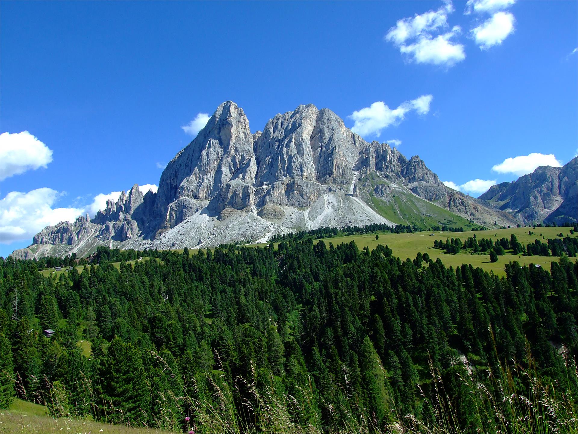
    Stage 2 goes from the Plose hut to Rifugio Genova, allowing trekkers to discover the wonders of the Puez-Odle Natural Park, often referred to as "Earth’s history book" due to its geological significance. Along the walk, the majestic Sasso Putia remains always in sight and offers many chances for a souvenir photo.

    Stage 3 connects the Rifugio Genova  to the Rifugio Puez. With an additional half an hour walk it is possible to climb to the top of Piz Duleda (2.909m), which offers a stunning view. Due to the multitude of rocks and interesting geological creations, the plateau of Puez is often compared to a moonscape. 

    Difficulté : moyenne
    1316 m altitude
    8h:19 min durée
    Hiking
    Hike from Nova Levante the Passo Costalunga
    Welschnofen/Nova Levante, Dolomites Region Eggental
    This hike from Nova Levante leads along a forest trail to the Passo Costalunga. Along the way you will also pass by the well-known alpine lake, the Lake Carezza, which is especially known for its deep green water and the beautiful mountain scenery in the background.
    Difficulté : moyenne
    688 m altitude
    3h:07 min durée
    Hiking
    Hike from Obereggen to Passo Costalunga
    Welschnofen/Nova Levante, Dolomites Region Eggental
    This hike, suitable for the whole family, leads from Obereggen through the Karerwald forest to the emerald-green Lake Carezza and on to the Passo Costalunga.
    Difficulté : moyenne
    337 m altitude
    3h:08 min durée
    Hiking
    Hut-tour Antermoia
    San Martin /San Martino, Dolomites Region Kronplatz/Plan de Corones

    It consists on a hut to hut hike, starting from Antermoia both in clockwise and in counter clockwise direction possible. From the typical mountain village of Antermoia you proceed to Alfarei and follow the indications for Montemuro, from where you descend on a path to the Pecol hut. Proceeding on the forestal road you reach the parking place Pé de Börz. You follow the path number 8, which leads you after ca. 45 pleasant walking minutes to the Passo delle Erbe where the next two alpine huts are waiting for you: Ütia de Börz and the Cir hut. After another 20 minutes through the marvellous flowering pastures which decorate the Sas Pütia you reach the Munt de Fornella. On your left you continue through the “Stone Village” and in ca. 35 minutes you reach the last of the planned alpine huts, that of Göma. From here you return to Antermoia on an easy path. Walking time: 6 h

    Difficulté : moyenne
    996 m altitude
    5h:25 min durée
    Hiking
    Hiking path: Sexten - Kreuzbergpass
    Sexten/Sesto, Dolomites Region 3 Zinnen
    Beautiful, less strenuous hike from Sexten to the Kreuzberg Pass with wonderful views of the mountain landscape of the Sexten Dolomites.
    Difficulté : moyenne
    355 m altitude
    2h:25 min durée
    Hiking
    Walk: San Vigilio - Passo Furcia
    Al Plan/San Vigilio, Dolomites Region Kronplatz/Plan de Corones

    Walk past the Miara cable car station and follow the road up to the hamlet Rara. Turn right onto forest path no. 1 which takes you to Passo Furcia, where a number of inns offer food and drinks. Take the same route to walk back. Alternatively to walking on the paved road, just behind the Chi Vai restaurant you can also take the pretty hiking trail which leads past the Riffa inn. After passing the eadows, you will find the path to the Spaces restaurant (stop here for food, drinks and a sun deck) on the left side at the edge of the forest. This route leads back to the main path (no. 1).

    Difficulté : facile
    533 m altitude
    1h:58 min durée
    Hiking
    Discovering the legend "The Salvan of the Gardena pass"
    Corvara, Dolomites Region Alta Badia

    Embark on a four-hour hike from Colfosco to Passo Gardena, and you will find yourself in the footsteps of the Salvan, the mythical little man of the forest who lived on the border with the Val Gardena.

    Discover the whole legend in the book: "Walking through an enchanted land" available in the tourist offices.


    Difficulté : moyenne
    659 m altitude
    4h:00 min durée
    Hiking
    Hike from the Gardena Pass to the Puez - Odle Nature Park
    Corvara, Dolomites Region Alta Badia

    The Puez-Odle Nature Park, a UNESCO World Heritage Site, is also known as "the witness to the geological history of the Dolomites". The natural park is particularly interesting from a geological and geomorphological point of view, with many typical rock formations and strata that are characteristic of the Dolomites.

    The hike in the south-eastern part of the Puez-Odle Nature Park presents no great technical difficulties for hikers.

    Difficulté : moyenne
    581 m altitude
    4h:32 min durée
    Hiking
    Hike: To the alpine pastures
    Sexten/Sesto, Dolomites Region 3 Zinnen

    Scenically beautiful Alpine ridgeway with views of the main peaks of the Sexten Dolomites.
    No car is necessary for this long, but not difficult, circular hike due to the dense network of trails, but you will need a good hiking map!

    Difficulté : moyenne
    1062 m altitude
    5h:30 min durée
    Hiking
    Hike Bad Bergfall - Furkelpass/Passo Furcia
    Al Plan/San Vigilio, Dolomites Region Kronplatz/Plan de Corones

    Starting from Bad Bergfall (accessible with the trekking bus n. 435.2) via hiking trail n. 4, then n. 4A to the Trattes mountain restaurant and then continue on hiking trail n. 3 to the Furkelpass.

    Difficulté : facile
    455 m altitude
    1h:37 min durée
    Hiking
    From Passo Valparola to Pralongiá and down to San Cassiano
    Badia, Dolomites Region Alta Badia

    An altidude hike from Passo Valparola to San Cassiano under the Setsas peak and to the Pralongiá plateau. Admire impressive views over the entire Alta Badia mountains with a close-up of the Lagazuoi top and the majestic peaks of Lavarela and Conturines. If you wish to extend your itinerary, you can even ascend the Setsas mountain.

    Difficulté : moyenne
    260 m altitude
    4h:19 min durée
    Mountaineering
    Alpine Tour: Knieberg
    Sexten/Sesto, Dolomites Region 3 Zinnen

    The Knieberg juts out a little from the Carnic Ridge extending south-eastwards from the peak of the Helm, offering outstanding views both of the Sexten Dolomites to the south-east and down into the Cadore-Piavetal valley. This trail still bears many traces of the First World War.

    Difficulté : moyenne
    942 m altitude
    6h:45 min durée
    Hiking
    Hike Planac - Cherz
    Corvara, Dolomites Region Alta Badia

    A pleasant and relaxing walk, on the plateau above Corvara, through flowering meadows and shady woods, with a stunnig view.

    Difficulté : facile
    246 m altitude
    2h:42 min durée
    Hiking
    Hiking path: From the meadows of the Croda Rossa to the Passo Monte Croce
    Sexten/Sesto, Dolomites Region 3 Zinnen

    An extremely scenic, six-kilometre high-altitude trail that follows old war trails and can also be recommended to less experienced mountain hikers, especially as the ascent can be done by lift and the way back by bus. The good trail leads from the Rotwand meadows, partly at the tree line, partly above it at the foot of vertical rockfalls, almost flat to the Kreuzberg Pass. From the path there are beautiful views of the Carnic ridge and the ice peaks of the Rieserferner group to the north. 

    Difficulté : moyenne
    270 m altitude
    1h:30 min durée
    Hiking
    WoodyWalk: The fun - Filled family hike on the Plose Mountain
    Brixen/Bressanone, Brixen/Bressanone and environs

    This short family hike is educational, exciting and fun, with several outdoor recreational opportunities to offer. Accessible to prams and strollers, this hiking trail on the Plose has magnificent views of the western Dolomites, particularly the striking Peitlerkofel and rocky peaks of the Geisler Group.

    Difficulté : facile
    184 m altitude
    1h:36 min durée
    Hiking
    Antermoia - Passo delle Erbe - Pütia Meadows
    San Martin /San Martino, Dolomites Region Kronplatz/Plan de Corones
    This two-hour hike takes you from the small village of Antermoia, over the Passo delle Erbe, to the vast alpine meadows that offer breathtaking views of the majestic rock massif "Sass de putia"
    Difficulté : moyenne
    588 m altitude
    2h:08 min durée
    Hiking
    Adventure hiking circuit Lorggen at Mount Plose
    Brixen/Bressanone, Brixen/Bressanone and environs

    Starting at the Plose gondola lift mountain station, follow the Lorggenring trail along the WoodyWalk before it branches off at a wide viewing platform. Stop for a minute and enjoy the view of the Dolomites before continuing into a dense woodland. Along the way, hikers learn about the Lorggen, ancient guardians of the forest and its inhabitants. From the Pfannspitz gondola lift valley station, you can quickly arrive at an elevation of 2,545 m. The view of the spectacular Geißler peaks and the surrounding mountains is absolutely phenomenal! Follow the trail along the ridge to the Plosehütte shelter, from where you can return to Kreuztal at the Plose gondola lift mountain station along trails no. 7 and then no. 3. This part of the circuit offers a magnificent panorama of the Brixen basin. The Lorggenring Hiking Circuit is also accessible to families with children, offering hikers of all ages a unique hiking experience on the slopes of the Plose.

    Difficulté : facile
    713 m altitude
    3h:00 min durée
    1