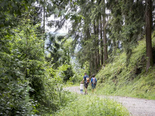
raspberry vines growing on the vertiginous slopes, help to make the Dursterhof quite unique.
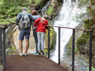
Le paysage est un cadeau dont tu peux profiter au mieux à pied. Au printemps dans le Sud-Tyrol, tu assistes au réveil de la nature dans la vallée et dans les prairies alpines en fleurs, tandis qu'en plein été, tu es attiré par les sommets aériens, les refuges recommandés et les randonnées en altitude. Les randonnées d'automne offrent une vue grandiose et des couleurs magnifiques. En hiver, la nature enneigée t'enveloppe lors de randonnées romantiques en raquettes et en hiver.
This hike leads you from the centre of Nalles to castle Katzenzungen, where the oldest and largest grapevine in the world is located.
Demanding hiking route on the Marling Höhenweg Trail with a beautiful view.
This picturesque hike along the Schenner Waal irrigation channel runs along an unspoilt trail through the chestnut grove and orchards high above the spa town of Merano, and is also thoroughly recommended for hot summer days.
The Laugenspitze is with 2.434 meters the highest mountain of the Nonsberg group in South Tyrol. Its striking double peak consists of the big Laugen and the small Laugen. The peak is accessible by several marked hiking trails. The easiest of these paths leads over the gentle south ridge.
Very worthwhile hike to the Monte Luco/Großer Laugen (2433m). Level of difficulty: moderate - fitness and sure-footedness necessary
This trail from Nalles to Andriano is an easy hike or suitable as a jogging track.
The Ultner Höfeweg farms hiking trail leads past ancient farmyards. Fantastic views of the surrounding mountains are available from here.
Taking just one and a half hours, the hike from Scena village center to Tirolo is very simple and easy to complete. There are interesting sights and lovely panoramic views to be enjoyed en route.
At an altitude of 2,355 m, the mining village on Schneeberg/Monte Neve is easily accessible – but only on foot. With its 800-year history, a unique landscape and gastronomic delights, the Schneeberg remains a highly-frequented tourist destination. In fact, the "Schneeberg" doesn't refer to a "mountain" as such – but rather to the whole mining complex. To the locals in the Passeiertal Valley, "Schneeberg" mainly refers to St. Martin/S. Martino's mining village that includes a mountain refuge with a restaurant and the Adventure mine; now a tourist attraction.
This easy, family-friendly hike leads from Verdins along the Wiesersteig track down to the village of Scena. Shady forests, blooming meadows and pretty farmhouses lend a truly special atmosphere to this hike.
This lovely circular hike winds through the scenery above Merano and offers leisure hikers the full range of scenic charms - shady woodland, blossoming meadows and rustic farms.
For generations, the path through the Masulschlucht gorge was an important link between Verdins and the mountain hamlet of Videgg. Yet, the path has also been the victim of nature’s cruel game… for example, the old bridge over the gorge was ripped away by the floods in the storm decades before and completely destroyed. Since then, the newly-installed wooden bridge offers breathtaking views of the lie of the land around the Masul torrent.
With this hike sure-footedness is needed. Take the Nachtigallensteig and the way no. 9 to the Castle Payersberg (private property). The hike continues along the secondary road and turns off, before Sirmiano di Sotto at a little chapel, left to Pitzon (refreshments). From the Bittnerhof you follow path no. 5B and then path no. 5 down to Nalles.
Waalwege are paths along the ancient irrigation channels. Ascend to the canal trail via the Kirchweg or Rösslweg streets. After approx. 300 m the Rösslweg branches to the left from the Kirchweg and rises gently to the shooting range where the Riffianer Waalweg trail begins. It runs between forest edge and meadows as far as Kuens/Caines and ends in the Kuensertal valley. Return either via the Kuenserstraße street, the Valtmaunweg trail or via the Hohlgasse street. If you wish, you can drive to the starting point in the Kuensertal valley by car, park there and then hike as far as Rifiano/Riffian (approx. 45 min).
The path is not suitable for pushchairs or strollers.
Experiencing the fascinating high Alpine lake plateau in South Tyrol
Both challenging for the considerably steep climb as well as its duration, this hike is also worth the effort with a spectacular mountain terrain and the fascinating high Alpine lakes.
Starting point: Pfelders/Plan
Endpoint: Pfelders/Plan
Refreshment stop: Faltschnalalm mountain hut, Lazinser Alm pasture, Lazins/Lazines
The porphyry hill of St. Hippolyt is situatet in the north of the low mountain range of Tesimo. The 758m high hill stands lonely, away from the noise of the world, and offers a unique panoramic view far over the Adige Valley. No fewer than 20 villages and 40 castles can be seen from up here. Its exposed location also made it one of the oldest prehistoric settlements in South Tyrol. The Romanesque church is only open on certain religious holidays.
The European hiking trail E5 is 3,200 kilometres long and leads from the Atlantic coast of France across the Alps to Venice. A highlight of the entire trail leads through the hiking area of Schenna, via the Hirzer Hut to the Meraner Hut on Meran 2000.
The European long-distance hiking trail E5 is 3,200 kilometers long and leads from the Atlantic coast of France, over the Alps, to Venice. A section of the long-distance hiking trail number 5 runs through South Tyrol in four stages, one of which goes through the Hirzer hiking area. From the Hirzerhütte hut (1,980 m), which was inaugurated in 1874 as the first Alpine Club hut in South Tyrol, it goes over the Hirzerscharte to the Kratzberger See at 2,128 m and further to the Meraner Hütte hut.
The climatic terrain cure is a special form of exercise therapy characterised by activity adapted to one’s fitness level, endurance training, and time spent in the outdoors experiencing the landscape, which is carried out through a personalised walking programme.
So-called terrain hiking improves endurance and agility, increases speed and flexibility, reinforces the cardiovascular system, stimulates breathing activity and strengthens muscles, ligaments and joints. It has a positive impact on the metabolism, activates the digestive system and noticeably increases the expenditure of calories.
The climatic terrain cure is recommended for functional cardiovascular disorders, respiratory and metabolic disorders, and above all is a tried and tested method of primary prevention and general health promotion.
The "Terrainkur" trails in Partschins/Parcines have been certified by the Ludwig-Maximilians-University of Munich.
Difficult yet rewarding hike for experienced hikers with a head for heights along the Vellauer Felsenweg trail with fabulous views of the Etsch valley.
Signposted as „Sonnenrundweg“ trail (Sun Path), this simple 1 hr. 45 min. hiking circuit crossing over sunny slopes and through shady woods leads off the parking lot near the church. In winter the wooded sections are ideal for snowshoe hiking.
Refreshment stops: Various taverns in Stulles
The trail is not suitable for pushchairs.
Starting from the inn Alpenrose the path leads to the church. Before reaching the church, turn left at a little supermarket and continue walking through meadows till you nearly reach the housing area “Sagstatt”. At the little chapel turn right and take the way uphill. You’ll pass the “Auerhof” and then continue walking to the “Wanserhof”. From there the path leads through meadows and forest and back to the inn “Innerwalten”. Follow the pavement for about 200 m till you reach the inn “Jägerhof”, then turn left and follow the signposts. After about 30 min. the path leads alongside the so-called “Römerweg” (path of the Romans), which leads to the Jaufen Pass. After about 200 m follow the signposts to the left and follow the meadow path uphill about 100 m and then take the forest path to the “Santlhof”. From there, you walk downhill to the inn “Alpenrose”, the starting point.
The Foiana Panoramic Trail (partly also a narrow mountain path) offers a breathtaking view of the Merano basin. The route begins behind the old Nagelehof farm at the crossroads. Turning left, follow trail no. 4 past the Gruberhof and Tratterhof. At the first left-hand bend the panoramic trail forks right. The path then runs level through the trees to the first viewing point, known as Kitzerknott, and after a somewhat steep descent to the second point, Schöne Aussicht. The hike continues to trail no. 9 which leads steeply downhill. At the Steinweiherhof, turn right, and once past the sports ground you will return to your starting point.
Exciting hike from Lana to Tesimo/Tisens
The climatic terrain cure is a special form of exercise therapy characterised by activity adapted to one’s fitness level, endurance training, and time spent in the outdoors experiencing the landscape, which is carried out through a personalised walking programme.
So-called terrain hiking improves endurance and agility, increases speed and flexibility, reinforces the cardiovascular system, stimulates breathing activity and strengthens muscles, ligaments and joints. It has a positive impact on the metabolism, activates the digestive system and noticeably increases the expenditure of calories.
The climatic terrain cure is recommended for functional cardiovascular disorders, respiratory and metabolic disorders, and above all is a tried and tested method of primary prevention and general health promotion.
The "Terrainkur" trails in Partschins/Parcines have been certified by the Ludwig-Maximilians-University of Munich.