Passer au contenu

ajouté(e) aux favoris

supprimé(e) des favoris

Oups ! Une erreur s’est produite. Réessayer

Ton compte est en cours de création

Ton compte a été créé avec succès et tu es maintenant connecté

Tu es connecté!

Ton compte a été créé avec succès, mais nous n'avons pas pu te connecter automatiquement

Tu es déconnecté

Filtrer
Filtres sélectionnés
    Niveau de difficulté
    Durée
    Distance en km

    Randonnées hivernales dans la station de ski d’Ortler


    Découvrez des points de vue spectaculaires dans la région de l’Ortler ou dans les Dolomites, des forêts enneigées dans des vallées latérales tranquilles sur la crête principale des Alpes et profitez de vous-même et de la nature dans un silence absolu. Cela fait de la randonnée hivernale une expérience.

    Résultats
    Hiking
    To the Beimstein Knott
    Vöran/Verano, Meran/Merano and environs

    The Beimstein Knott is one of three tuff knolls. These three tuff knolls are of volcanic origin and are unparalleled in South Tyrol. Additionally is impressive for its stunning view overlooking the village of Vöran.

    On the red rock is placed a new installation, called “Attimo” installation. It is comprised of five chairlift seats placed in a row, representing an imaginary chairlift.

    Difficulté : moyenne
    146 m altitude
    1h:08 min durée
    Hiking
    Knottnkino in Vöran - Short hike
    Vöran/Verano, Meran/Merano and environs

    The Knottnkino is a lookout point. It's outfitted with thirty cinema seats, where the hikers can take a seat and enjoy the unique experience: nature as cinema. The site overlooks the whole of the Adige Valley so visitors enjoy stunning views that encompass the Texel Mountains, Mount Penegal, and even Weißhorn farther afield.


    Difficulté : facile
    184 m altitude
    0h:40 min durée
    Hiking
    Sluderno Biotope
    Schluderns/Sluderno, Vinschgau/Val Venosta

    These wetlands, known as Schludernser Au or Schludernser Erlenwaldbiotop alder biotope became a protected site in 1976 and cover an area of about 140 hectares. These meadowlands are the biologically most productive habitats with the greatest biodiversity. The education trail through alder woods, ponds, natural streams and rough gravel with 12 information boards in the Natura 2000 region, a veritable treasure trove of life and a refuge for endangered animals and plants.

    Difficulté : facile
    20 m altitude
    1h:00 min durée
    Hiking
    rumbling tour: Resia - Vallierteck - Froj
    Graun im Vinschgau/Curon Venosta, Vinschgau/Val Venosta
    You walk past the stations of the Way of the Cross (each around 300 metres long) until you reach the end of the hike, a charming little church in the middle of a dense forest.
    Difficulté : facile
    252 m altitude
    1h:04 min durée
    Hiking
    Winter hike to the Kuhalm
    Sterzing/Vipiteno, Sterzing/Vipiteno and environs

    Snow shoe hiking trail with a splendid panoramic view on the Sterzing basin. The Kuhalm mountain hut is not opened in winter.

    Difficulté : facile
    176 m altitude
    1h:10 min durée
    Hiking
    Knottnkino in Vöran
    Vöran/Verano, Meran/Merano and environs

    The Knottnkino (Knott meaning rock, kino meaning cinema) is one of the most beautiful viewpoints in Vöran/Verano and is located upon the Rotstein Knott mountain. In the seats made from steel and chestnut wood designed and positioned by the artist Franz Messner from Ritten/Renon, one can enjoy unique views of the Texelgrupperange all the way to Penegal mountain and the Weißhorn peak, as though sitting comfortably in a cinema. But the film is always changing in the Knottnkino: daily, hourly, with the time of day and the changing of the season, with the climate and weather, there is always something new to see...

    Difficulté : moyenne
    326 m altitude
    2h:40 min durée
    Hiking
    To the little St. Kathrein Church
    Hafling/Avelengo, Meran/Merano and environs

    The famous little church in St. Kathrein is situated on a rise in Hafling and can be seen from far away in Meran and Environs. The Romanesque church has its origins in the 13th century and features well-preserved frescos from the 14th century. Fantastic views of the city of Meran as well as the Texelgruppe range can be enjoyed from the church.

    Difficulté : facile
    89 m altitude
    0h:45 min durée
    Hiking
    To Leadner Alm Mountain Hut
    Vöran/Verano, Meran/Merano and environs

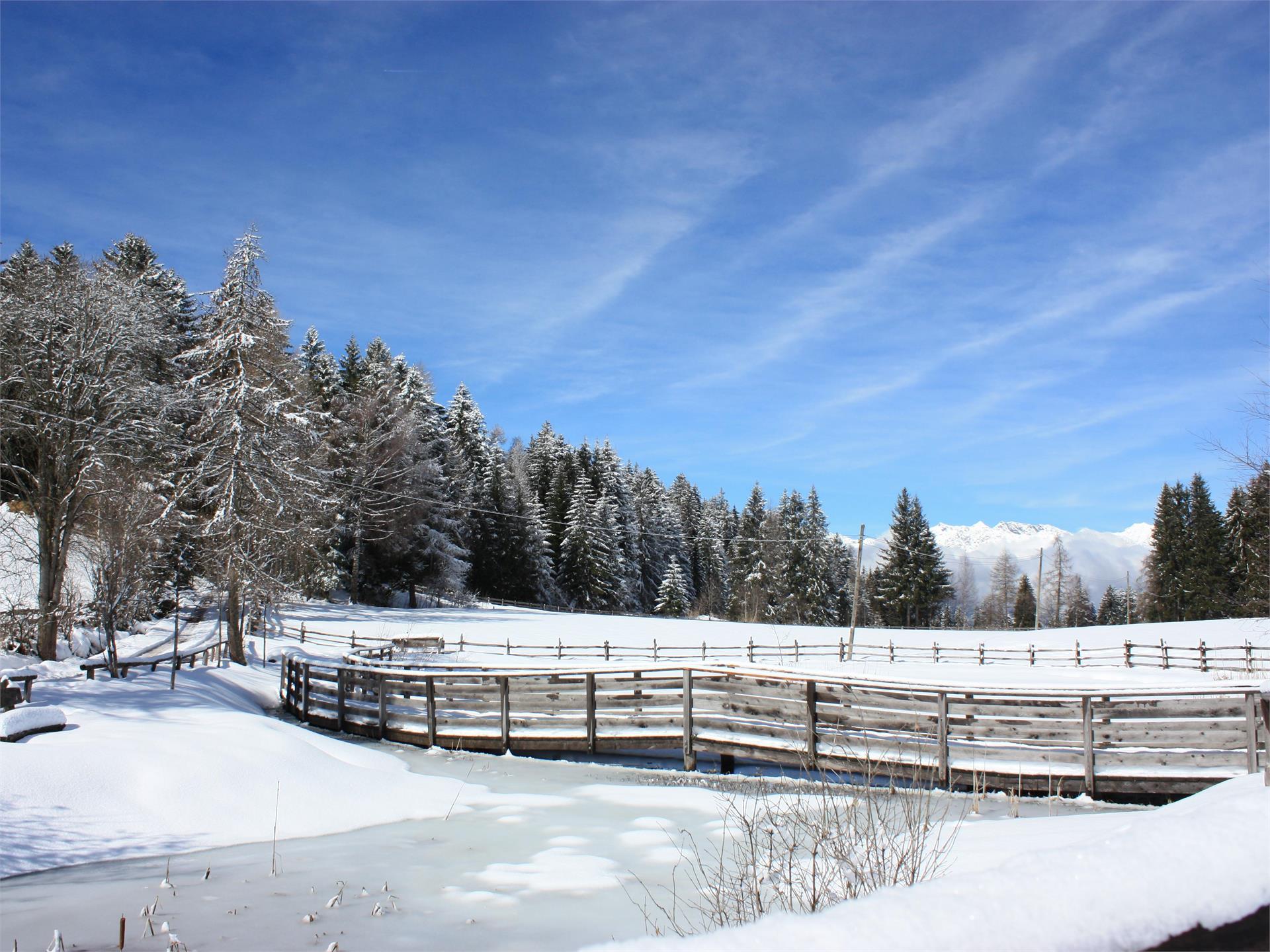
    This hike is an easy and family-friendly route which can even be done with a buggy. The Weiher Bruggen pond is one of the attractions: it is a resting place for young and old. Parents can enjoy the view toward the Ifinger mountain whilst children can admire the many fish in the pond.

    Difficulté : facile
    276 m altitude
    2h:15 min durée
    Hiking
    To the Ochsenberg alpine pasture
    Vinschgau/Val Venosta
    At the beginning of the hike, starting from the hamlet Kapron in Langtaufers valley, it is difficult to imagine the paradise that awaits you: The first ascent to the Ochsenberg mountain is fairly steep, but flattens after the first part of your hike. After 30 minutes you are surrounded by the most beatutiful scenery, at which to marvel. By following the path no. 14 you soon reach the Ochsenbergalm alpine pasture (not farmed) with the chapel St. Wendelin located at 2,160 m in the middle of this beautiful valley. The way back to Riegl follows the same route as the one going there.
    Note: After the first few metres of the hike, a small signposted path branches off the main route. This is a very steep shortcut to the alpine pasture.
    Difficulté : moyenne
    510 m altitude
    2h:30 min durée
    Hiking
    Knottnkino in Vöran - start at the bus stop "Alpenrose"
    Burgstall/Postal, Meran/Merano and environs

    The Knottnkino is a lookout point. It's outfitted with thirty cinema seats, where the hikers can take a seat and enjoy the unique experience: nature as cinema. The site overlooks the whole of the Adige Valley so visitors enjoy stunning views that encompass the Texel Mountains, Mount Penegal, and even Weißhorn farther afield.

    Difficulté : facile
    180 m altitude
    0h:40 min durée
    Hiking
    Easy hike from Vöran to Hafling
    Hafling/Avelengo, Meran/Merano and environs

    This easy hike from Vöran/Verano to Hafling/Avelengo is suitable for everyone and even doable with a stroller. There are several places to stop and eat along the way -all of which have terraces with delightful views.

    Difficulté : facile
    150 m altitude
    1h:45 min durée
    Hiking
    To the mountain hut Maseben
    Vinschgau/Val Venosta
    Kappl, a hamlet at the far end of Langtaufers valley, is the starting point of the hike and also the place where the car park is located. From there you walk towards the out of service Maseben ski-lift station, cross the Karlinbach river, climb up the former ski slope to the forest road signposted no. 15 on your left for about 600m, then keep to the right on the path signposted no. 19. Via the forest road, you climb through the forest, passing the old mid station, the Masebener Alm alpine pasture and the ski-lift, which is still in use in winter, and you reach your destination, the Maseben mountain hut. Once you arrive at the mountain hut, you can enjoy an amazing panoramic view of the surrounding mountains at 2,200m. The descent follows the same route as the one going up.
    Note: There is also an option to take the shuttle service, which takes guests to the mountain hut via an adventurous journey.
    Difficulté : moyenne
    445 m altitude
    2h:45 min durée
    Hiking
    Hiking: Curon - Salg - Arlundo
    Graun im Vinschgau/Curon Venosta, Vinschgau/Val Venosta

    From the end of the village near the St. Anna chapel right up to the forest, there turn left to "Salg", continue on the forest road to the hamlet of Klopair with descent to Resia or descent to Arlund and back across the sea to Graun.

    Difficulté : facile
    516 m altitude
    3h:12 min durée
    Hiking
    Knottnkino - Hike starting from Hafling
    Hafling/Avelengo, Meran/Merano and environs

    The Knottnkino in Vöran/Verano is a lookout point. It's outfitted with thirty cinema seats, where the hikers can take a seat and enjoy the unique experience. The site overlooks the whole of the Adige Valley so visitors enjoy stunning views that encompass the Texelgruppe Mountains, Mount Penegal, and even Weißhorn farther afield.

    Difficulté : moyenne
    507 m altitude
    3h:58 min durée
    Hiking
    Burgusio - San Valentino alla Muta
    Mals/Malles, Vinschgau/Val Venosta
    Hiking tour to the lake Haidersee along the Adige River
    Go from the market place in Burgeis to the Gasthaus Gerda inn, straight on along the Adige River to S. Valentin Lake. Start of the hike around the lake at landing (No. 1). After the circuit 2 trails lead back to Burgeis: 1: the same way back, along the Adige River (marked as a bike path); or 2: at the end, follow trail No. 5A to the Faulen See Lake and use trail No. 4 to the mountain lake. From here take trail No. 3 back to the village of Burgeis.
    Difficulté : moyenne
    245 m altitude
    3h:30 min durée
    Hiking
    To the Melager Alm alpine pasture
    Graun im Vinschgau/Curon Venosta, Vinschgau/Val Venosta
    The route from Melag/Melago to the Melager Alm alpine pasture in Langtaufers valley is a beautiful family hike, which is also suitable for buggies. The hike starts from the car park in the hamlet Melag, the highest hamlet in Langtaufers valley at 1,915m, which is inhabited all year round. From the car park walk to the right between the houses. Signpost numbers 2 and 5 indicate the path, but it is impossible to miss even without the directions. In a very gentle ascent walk towards to the bridge over the Karlinbach river. Cross the bridge and continue on the flat path towards the alpine pasture. At the end of the valley, the snow-covered peaks around the Weißkugel rise up; to the north and south, a whole series of three thousand metre peaks flank the valley. The way back follows the same route as the one going there.
    Note: As an alternative you can start this hike from the hamlet of Kappl at the out of service Maseben ski-lift station and follow the forest road to the Melager Alm alpine pasture.
    Difficulté : facile
    135 m altitude
    1h:30 min durée
    Hiking
    Winter Circular Hike to the Flaner Jöchl Ridge on the Rosskopf
    Sterzing/Vipiteno, Sterzing/Vipiteno and environs

    The winter circular hike to the Flaner Jöchl at Rosskopf / Monte Cavallo ridge is an easy panoramic hike for all the family on Sterzing’s / Vipiteno local mountain. The well-prepared trail leads through the snowy mountain and woodland landscape across the valley basin and offers wonderful views of the surrounding mountains. From the nearby Sarntal Alps where the hike begins, to the view of the mountains of the Pfitschtal valley in the foreground and the peaks of the Dolomites on the horizon, through to the view into the Pflerschtal valley: a range of winter worlds present themselves to hikers as they walk along.

    Difficulté : facile
    160 m altitude
    2h:00 min durée
    Hiking
    Brugger Alm Alpine Pasture – Zerzertal valley in winter
    Mals/Malles, Vinschgau/Val Venosta
    Explore the snow-covered winter landscape in the idyllic Zerzertal valley towards the Brugger Alm. A beautiful, moderately difficult snowshoe or winter hike with picturesque views.
    No refreshments available at the Brugger Alm.
    Difficulté : moyenne
    504 m altitude
    2h:47 min durée
    1 2 3