Přeskočit na obsah

přidáno k oblíbeným

odebráno z oblíbených

Jejda! Došlo k problému, zkuste to prosím znovu

Vytváří se váš účet

Váš účet byl úspěšně vytvořen a nyní jste přihlášeni

Jste úspěšně přihlášeni!

Váš účet byl úspěšně vytvořen, ale nepodařilo se nám vás automaticky přihlásit

Jste odhlášeni

Filtr
Vybrané filtry
    Úroveň obtížnosti
    Doba trvání
    Vzdálenost v km

    Objevte krásy Jižní Tyrolsko Vinná cesta

    Jižní Tyrolsko vinicemi vás okouzlí svými vinicemi a pohostinností.
    Výsledky
    Hiking
    Brenntalweg to Kurtatsch
    Tramin an der Weinstraße/Termeno sulla Strada del Vino, The South Tyrolean Wine Road
    Through the vineyards to Kurtatsch

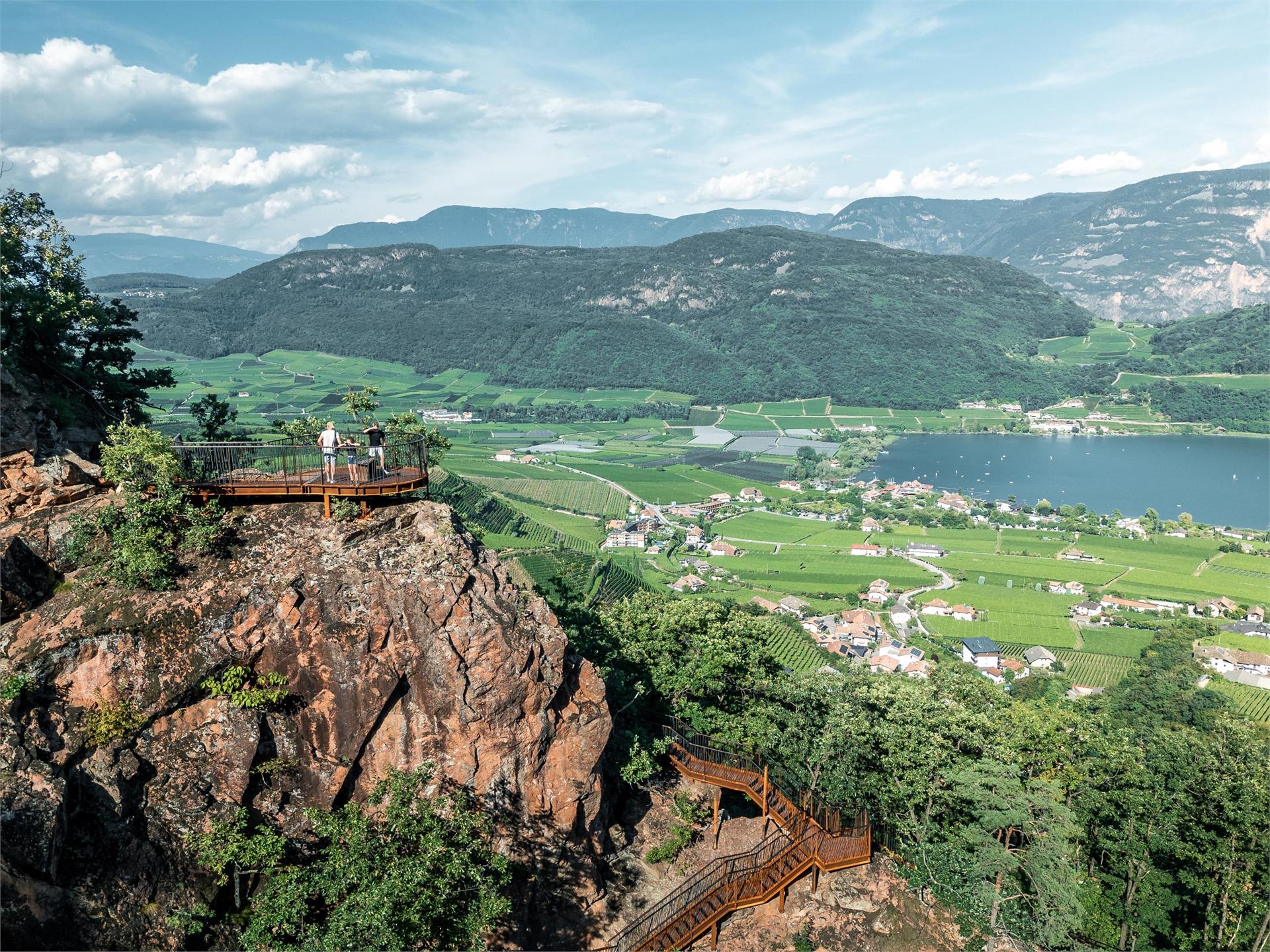
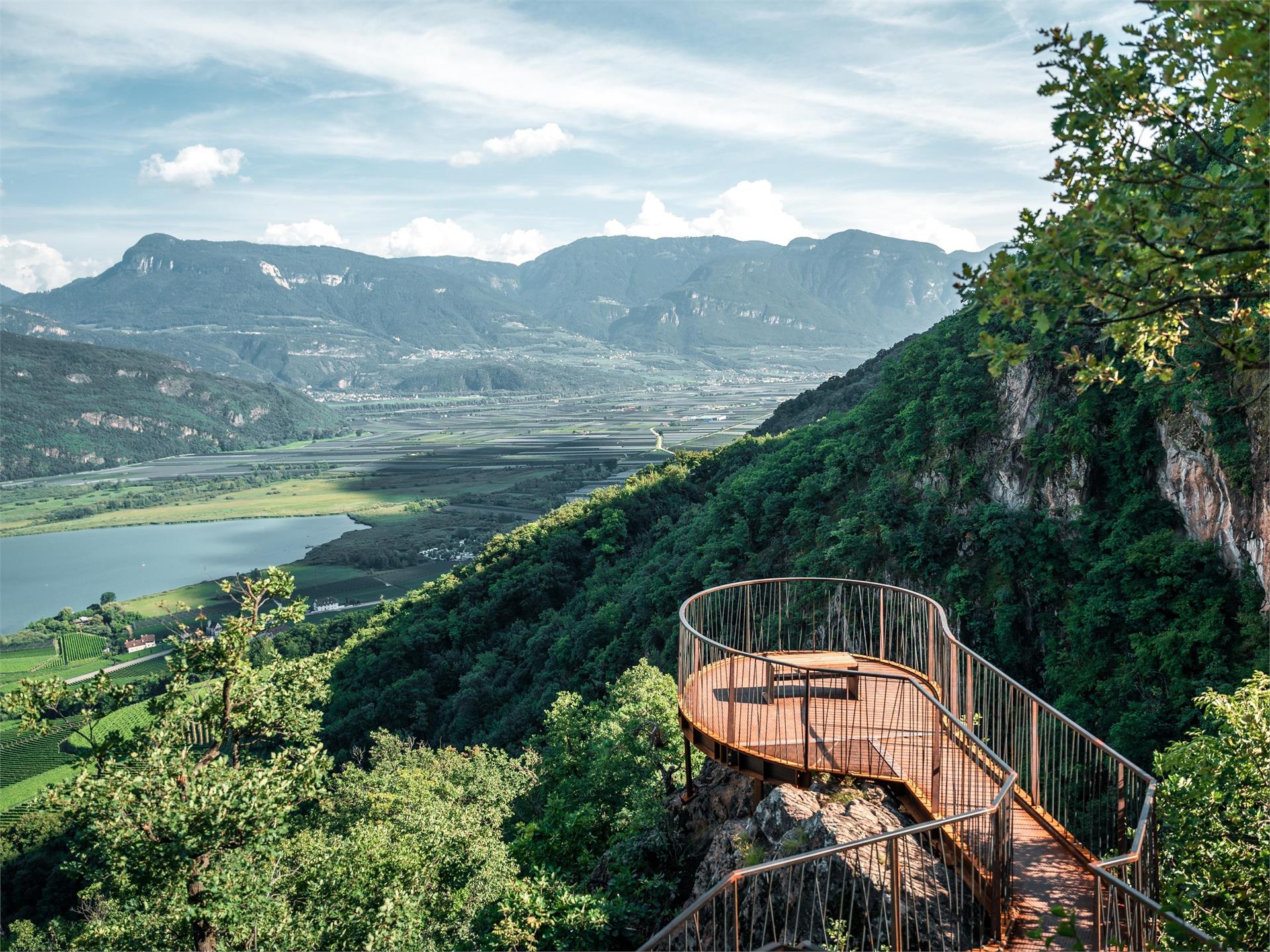
    We hike to the wine road - junction Neumarkt/Kurtatsch and after 30 m turn left into the Brenntalweg. Follow this asphalted road for about 3 km. Continue straight on and you will see signs for the "Millastiege". We follow these and climb up through the rocks to the wine road before the village of Kurtatsch.

    For the way back we take the hiking trail Kastelaz or the less frequented panoramic road via Rungg. You will find the corresponding signs in the village of Kurtatsch.
    Obtížnost: nízká
    434 m nadmořská výška
    2h:43 min doba trvání
    Hiking
    Trail f | Truden - Schwarzhorn - Jochgrimm
    The South Tyrolean Wine Road

    This challenging hike from Truden via the Schwarzhorn and all the way to the Jochgrimm is a unique adventure. From Truden, you'll first proceed uphill to Kaltenbrunn (refreshment stop and access to public transportation). From here, you can then proceed to the famous "Ice Holes" – an unusual phenomenon where cold air streams out of holes in the ground even on the hottest days of summer. You will then proceed steadily uphill via the challenging "Leitensteig" staircase until you come to the Kugeljoch; from this pass, you have a magnificent panoramic view of the Fleims Valley. From the Kugeljoch, you will continue to the Schwarzhorn (2,439 meters above sea-level). Finally, you follow the descending path to the Jochgrimm, the goal of this tour. This hike offers a wealth of unique natural beauty and is – in spite of the level of difficulty – an absolute "must" for ambitious hikers.

    Obtížnost: vysoká
    1716 m nadmořská výška
    6h:05 min doba trvání
    Vie Ferrate
    Überetscher Hütte - Roen (Klettersteig)
    Tramin an der Weinstraße/Termeno sulla Strada del Vino, The South Tyrolean Wine Road

    From the festival place the via Molino up, to the forest road. The wood sign “Gummererhof” points us the direction. Starting from the “Gummerhof” moving way nr. 10 to the steep “Weiße Rissen” and the “Kleinen Göller” (water place), left up to the marking T from Termeno, leads into our moving way. Through seal coniferous forest, way nr. 523, further, past at the hunter hut, up to the waterfall, then 20 min. laborious rise to the “Rifugio Oltradige – Überetscher Hütte” (mountain inn).

    To reach the peak of Roen from the „Überetscher Hütte“ there exist two variants:
    1) for those who are ambitious and doesn’t suffer from vertigo: via ferrata (marking 523), to the peak of Roen (2116m above sea level), then down through meadows (marking 500) to the mountain pasture of Roen, and again to the „Überetscher Hütte“.
    2) The marking 10/560 in the northward direction until the mountain pasture of Roen and over the trail (marking 500) to the Roen. The way back to the Passo della Mendola or descend through the „Tauris“ (marking 10A) direct to Tramin.

    Obtížnost: střední
    2610 m nadmořská výška
    8h:18 min doba trvání
    Hiking
    Trail d | Gfrill - Altrei
    The South Tyrolean Wine Road

    On this segment, you will proceed first from Gfrill to the bogland lakes of the "Weiss" and the "Schwarz." From there, the route continues to the Horn-Alm, the highest point of the segment. Hikers can stop here for refreshments and then continue downhill via the Ziss Saddle – not far from there, you can admire the stunning "huckete Stoan," a free-standing erratic boulder made of porphyry the size of a house – until you come to Altrei.

    Obtížnost: střední
    467 m nadmořská výška
    3h:42 min doba trvání
    Mountaineering
    Hiking tour Mendelpass-Roen
    Kaltern an der Weinstraße/Caldaro sulla Strada del Vino, The South Tyrolean Wine Road

    Beautiful, not difficult mountain-hiking tour with gentle gradients. Starting point: mountain station of the Mendel Cable Car/Mendel pass. Endpoint: peak Roen (2116 meters). Walking time: about 3.5 hours. Difference in altitude: about 750 meters.

    Obtížnost: střední
    750 m nadmořská výška
    3h:30 min doba trvání
    Hiking
    The Pinot Noir Trail
    Auer/Ora, The South Tyrolean Wine Road

    The Pinot Noir Trail in the south of South Tyrol is a new educational path where you can learn more about our land’s culture and its wines. It winds through the famed Pinot Noir vineyards and along the Trudner Horn Nature Park. It starts at the quaint villages of Auer, Montan, and Neumarkt in the Unterland district and leads you through Italy’s best Pinot Noir terroirs in Mazon, Glen, and Pinzon. You can choose between a 16-km-long one-day outing or three half-day tours.
    Along the way, hikers and strollers will encounter various historical spots and cultural highlights – e.g., the significant archeological sites of Castelfeder, the oldest segment of the Fiemme Valley railway, St. Stephan’s Church in Pinzon with its late-Gothic Altar by the Master Hans Klocker, the idyllic St. Michael’s Church in Mazon, the ruins of Kaldiff, and the handsome Enn Castle. Along the way, information panels and interactive stations will help you learn more about this unique wine-growing area and its history. You’ll be rewarded with stunning views of the Unterland district. The differences in elevation shouldn’t be a problem as most of the route is relatively level. But there’s a lot to explore and discover, for young and old alike! It’s easy, comfortable, and suitable for
    families. The route is open 12 months a year. A red “B” will lead the way.

    Obtížnost: střední
    607 m nadmořská výška
    4h:49 min doba trvání
    Hiking
    Kurtatsch/Cortaccio – Penon/Penone - Kurtatsch/Cortaccio
    Margreid an der Weinstraße/Magrè sulla Strada del Vino, The South Tyrolean Wine Road

    From the main square, we follow the initially steep Obergasse. After traveling about 100 meters - at the little square – we turn to the right. At the next junction - the fountain – we take the Maria-Hilf Gasse to the left, passing by farms and tall old poplars until it meets the road to Graun. After about 100 meters turn left on a narrow side road - marking 2 - leading to the hamlet Hofstatt (608 m). Change to the Graun road until shortly after Gasthof Halbweg where the road leads left to an asphalt road at the Himmelspfort inn – with the possibility of a detour to the village center of Penon (605 m). To return, turn right just after the restaurant at the Himmelspfort. Over a narrow path leading through vineyards, the trail climbs down and soon reaches the paved road that leads to Kurtatsch.


    Obtížnost: střední
    0 m nadmořská výška
    15h:04 min doba trvání
    Local tours
    Walk to the waterfall in Vilpian
    Tisens/Tesimo, The South Tyrolean Wine Road

    From the center of Vilpiano you take the Brauereistraße following the indications "Wasserfall". The path leads from the Vilpian village center in about ten minutes, past the state fire brigade school, to the waterfall. This is 82 m high and a natural monument. The “Waal” (way along the waterways), which is visible on the last stretch of the way, used to be used to irrigate the fields.
    This walk is particularly recommended in summer.

    Obtížnost: nízká
    26 m nadmořská výška
    0h:09 min doba trvání
    Hiking
    Tramin to the Rastenbach gorge
    Tramin an der Weinstraße/Termeno sulla Strada del Vino, The South Tyrolean Wine Road

    From the town hall square to the fairground, Söllerstraße, after the Hotel Winzerhof turn right into a vineyard path and follow the nature trail (11+11 A) to Lake Kaltern. Turn left at the Hotel Seeleitenhof and follow the signs for "Rastenbachklamm". This is followed by a varied hike over paths, steps, platforms, bridges and past waterfalls and a stream, through the wild and romantic gorge up to Altenburg. Also worth seeing along the way are the ruins of St. Peter, just before Altenburg. Return via Altenburg, Panoramaweg and Römerweg (11) to the Söll fire station and at Hotel Plattenhof back down the nature trail to Tramin.

    Duration: 4.5 - 5 h

    Difference in altitude: 350 m (circular route)

    Obtížnost: střední
    776 m nadmořská výška
    4h:40 min doba trvání
    Hiking
    Trail f2 | Radein - Jochgrimm - Schwarzhorn
    The South Tyrolean Wine Road

    This segment begins in Oberradein. Follow the Zirmersteig staircase uphill through the increasingly sparce high-alpine vegetation until you come to the Weisshorn (2,317 meters above sea-level). Here you can enjoy the fabulous panoramic view before embarking on the return trip down to the Jochgrimm. There are various refreshment options as well as plenty of opportunity to admire the very diverse flora of the alpine meadows. After a short breather, the segment goes up to the Schwarzhorn (2,439 m above sea-level).

    Obtížnost: vysoká
    1263 m nadmořská výška
    4h:34 min doba trvání
    Hiking
    A panoramic walk along the Fleims railway track
    Truden/Trodena, The South Tyrolean Wine Road

    This excursion follows the old railway line of the Val di Fiemme. This railway line was built during the First World War and between 1918 and 1936 was mainly used for freight traffic. The walk winds along the sunny slope, among lovely vineyards. This panoramic tour is particularly worthwhile for the wonderful views over the Bassa Atesina.

    Obtížnost: střední
    754 m nadmořská výška
    3h:23 min doba trvání
    Hiking
    Hiking tour Valley "Frühlingstal"
    Kaltern an der Weinstraße/Caldaro sulla Strada del Vino, The South Tyrolean Wine Road

    Not difficult path with some grades. Due to the countless spring flowers this hiking tour is especially recommended in the period end of February - beginning of March. Start- and final point: historical centre of Caldaro/Kaltern. Duration of walking: about 3.5 hours. Different of altitude: about 170 meters.

    Obtížnost: nízká
    0 m nadmořská výška
    3h:30 min doba trvání
    Running and fitness
    Three lakes trail
    Kaltern an der Weinstraße/Caldaro sulla Strada del Vino, The South Tyrolean Wine Road

    Impressive trail from Lake Caldaro to both of the Monticolo lakes and back. The excursion cuts across the varied terrain and requires, due to the considerable length, a good physical condition. Not pram-friendly.

    Obtížnost: vysoká
    29 m nadmořská výška
    0h:19 min doba trvání
    Mountaineering
    Hiking Tour St. Anton-Göller-Prazoll
    Kaltern an der Weinstraße/Caldaro sulla Strada del Vino, The South Tyrolean Wine Road

    Moderately difficult mountain-trail with steep sections. Starting- and endpoint: sport area S. Antonio/St. Anton. Walking time: about 7-8 hours. Difference in altitude: about 1230 meters.

    Obtížnost: vysoká
    1200 m nadmořská výška
    7h:00 min doba trvání
    Running and fitness
    Lime tree trail
    Kaltern an der Weinstraße/Caldaro sulla Strada del Vino, The South Tyrolean Wine Road

    Beautiful trail which winds its way across the upper part of the Castelvecchio forest exclusively on forest tracks and roads. The wood offers plenty of shade which is why this trail is especially ideal during summer. Drinking fountain at the highest point of the trail.

    Obtížnost: vysoká
    29 m nadmořská výška
    0h:19 min doba trvání
    Hiking
    Trail f2 | Jochgrimm - Schwarzhorn - Radein
    The South Tyrolean Wine Road

    From Jochgrimm first up to the Schwarzhorn (2,439 m above sea-level), where you are immediately rewarded with a great panoramic view. From here it goes back again to Jochgrimm and then up to the magnificent Weisshorn (2,317 meters above sea-level), once again you can enjoy a splendid panoramic view. You will then proceed through increasingly dense vegetation downhill and along the Zirmersteig staircase until you reach Oberradein, an idyllic village surrounded by verdant meadows and lush forests.

    Obtížnost: střední
    814 m nadmořská výška
    3h:52 min doba trvání
    Hiking
    Lake Kaltern hiking tour
    Kaltern an der Weinstraße/Caldaro sulla Strada del Vino, The South Tyrolean Wine Road
    This family-friendly circular hike is accessible all year round. Lake Kaltern, as the warmest bathing lake in the Alps, is a must for every South Tyrolean friend!
    Obtížnost: střední
    32 m nadmořská výška
    1h:55 min doba trvání
    Running and fitness
    Dschibuti trail
    Kaltern an der Weinstraße/Caldaro sulla Strada del Vino, The South Tyrolean Wine Road

    Demanding running trail which requires plenty of stamina. The long trail will reward runners with a diverse stretch and a beautiful scenery across Lake Caldaro. Pace yourself while running around the lake because the somewhat longer climb to Caldaro should not be underestimated.

    Obtížnost: vysoká
    282 m nadmořská výška
    2h:19 min doba trvání
    Running and fitness
    Lake Caldaro
    Kaltern an der Weinstraße/Caldaro sulla Strada del Vino, The South Tyrolean Wine Road

    Easy stroll around Lake Caldaro. Gentle incline. If you wish to avoid one of the uphill climbs, we recommend you start the circular trail heading towards the south. However, nothing stops you from heading in the opposite direction. Tip: The straight stretch in the southern part of the excursion is ideal for interval running or sprints. We recommend you take this excursion during the morning.

    Obtížnost: nízká
    29 m nadmořská výška
    2h:00 min doba trvání
    Hiking
    Bärental
    Kaltern an der Weinstraße/Caldaro sulla Strada del Vino, The South Tyrolean Wine Road
    Accessible from the village via the San Antonio sports area, the Bärental hiking trail is both a hiking option to Lake Kaltern and an access route to the lower part of the Rastenbach gorge. Not new, but with a new look and a new platform, this trail offers space for spending time in nature and spectacular views around the lake and the Rastenbach gorge itself. For the Bärental hiking trail, just follow the no. 13 signpost and discover the forest of Castelvecchio, the gorge, the steps and the newly constructed stairs. The new viewing platform offers an additional opportunity for a panoramic view. The only requirement for this hike is the ability to withstand heights.
    Obtížnost: střední
    322 m nadmořská výška
    2h:00 min doba trvání
    Local tours
    Art-historical walking tour Tramin
    Tramin an der Weinstraße/Termeno sulla Strada del Vino, The South Tyrolean Wine Road
    The starting point of our tour around the historic centre of Tramin is the Rathausplatz. This square is named after the town hall - an attractive building whose present appearance only dates from the 19th century.
    The real landmark of the town is: the parish church. The parish church is dedicated to St. Quirikus and Julitta and is a foundation of the Langobardic Count Rodengo, around 850.
    The choir room was constructed towards the end of the 14th century, but the nave with the side naves were only built in 1911. The frescoes in the choir room on the right side point to the ordeal of Julitta (mother) and Quirikus (son).
    The main altar was erected in place of a precious gothic altar at the end of the 18th century (today in the Bavarian national museum, a work by Master Klocker, pupil of the famous Michael Pacher). The altarpiece comes from Martin Knoller, a significant South Tyrolean painter.

    We continue our tour and visite some other interesting buildings:
    The manor of the Langenmantel family, which – from a feudal perspective – is reminiscent of better times. Let us look for instance at the marble blazon with the inscription RR, a hint to the progenitor Rüdiger von Langenmantel. In the 15th century, a branch of the noble family moved from Augsburg (Germany) to Tramin where they achieved prosperity and political influence and hence erected a stately home to demonstrate their status.
    In the manner of the so-called “Clesian Renaissance”, the doors and windows of the manor were garlanded with elegant marble frames, and a fine oriel came to embellish the north-eastern corner of the residential wing.

    The most famous work of art in Tramin and one of the most famous throughout the region depicts the little St. Jakob’s church on a hill overlooking the village. Still in very good condition there’s a Roman fresco cycle from around the time 1220. What you might normally recognise as stony sculptures can be admired here as a colourful painting. Strange hybrids made of man and animal populate the walls of the altar room. Fish and birdmen fighting with each other, a cenotaph a figure with a dog’s head a skiapod and other fantasy figures from the middle ages clearly embody the sinful contrast to the dignified Apostles and Christ of the mandorla. But the paintings finished by Ambrosius Gander according to inscriptions from 1441 in the southern wing where amongst others the famous legendary pilgrims get told through high quality ad colourful pictures are worthy of note.

    Come and discover the history of Tramin.
    Obtížnost: nízká
    0 m nadmořská výška
    0h:00 min doba trvání
    Local tours
    Guide church
    The South Tyrolean Wine Road

    Guided tour with visit of the tower through the church, named as well “cathedral of the countryside”.
    10.00 am, meeting point in front of the church of St. Pauls | Eppan
    Duration approx 1,5 hours
    Costs € 5 per person

    Obtížnost: nízká
    0 m nadmořská výška
    1h:30 min doba trvání
    Hiking
    Trail for the familiy Kastelaz (Termeno-Cortaccia)
    Tramin an der Weinstraße/Termeno sulla Strada del Vino, The South Tyrolean Wine Road

    Walking time: about 2.5 hours

    Starting point: Town Hall Square. Via Schneckenthaler Straße to St. Anna Nursing Home. Immediately after, turn left following the sign "Hiking Trail Kastelaz" up to the forest road. This leads first slightly uphill and then gently downhill through sparse mixed forest for 3 km to the neighboring village of Kurtatsch. In 2024, 5 new play stations for children were built. Right at the beginning of the hiking trail, children can now whizz down a rapid slide. A few steps ahead, a wooden snake invites balancing. Followed by a swing, a climbing igloo, and at the rest area "Bödala," a cable car. Right at the first houses of Kurtatsch, we reach via the less traveled panoramic road above the Wine Road via Rungg back to Tramin. (Opportunities to stop for food in Kurtatsch and at the Hofschank zur Pergola in Rungg, closed on Wednesdays).

    Obtížnost: nízká
    261 m nadmořská výška
    2h:30 min doba trvání
    Hiking
    Trail e | Truden - Altrei
    The South Tyrolean Wine Road

    This route will lead you through the Truden Horn Nature Park from the multi-faceted alpine village of Truden all the way to the charming little village of Altrei. The trail is first uphill to the Krabes-Alm, at an elevation of 1,540 meters above sea-level; this is a good place to stop for a short rest. You will then proceed along a forest trail until you come to the high-altitude bog of "Langes Moos." Then you can return to Altrei via an old cobblestone path.

    Obtížnost: střední
    429 m nadmořská výška
    2h:55 min doba trvání
    Running and fitness
    Peace Path
    Kaltern an der Weinstraße/Caldaro sulla Strada del Vino, The South Tyrolean Wine Road

    A nice stroll across Castelvecchio forest. The wood offers plenty of shade which is why this trail can be experienced all year round. There is barely any elevation gain, only some gentle inclines and descents. A particularly rewarding trail in spring and autumn, as you can admire the special play of colours of the forest during these seasons.

    Obtížnost: střední
    29 m nadmořská výška
    0h:19 min doba trvání
    Hiking
    Nature Experience Trail Tramin
    Tramin an der Weinstraße/Termeno sulla Strada del Vino, The South Tyrolean Wine Road
    Family hike featuring beautiful views of the Lake Kaltern.
    The many display boards inform interested hikers about the diverse flora and fauna and the geological discoveries of the region, making the Nature Experience Trail in Tramin a special experience for young and old.

    From the Rathausplatz (town hall square), head along Hans-Feur-Staße street, the town’s main road, till you come to the fairground where you turn left into the Mühlgasse alley. Follow thus until turning right at a junction. After crossing over a bridge, you will see the Hotel Winzerhof.
    On the curve after the Hotel Winzerhof just follow the path 11 and walk straight ahead. The trail first leads through vineyards, then heads gently upwards through mediterranean mixed forest to the restaurant Plattenhof (closed on Monday) in Sella/Söll. On the way there are some small views on the Caldaro lake. At the Hotel Plattenhof, direction Caldaro lake, turn to the left and follow path 11A for approx 20 minutes and then leave the trail and turn to the right. After 50 minutes you will be back at Tramin.
    Obtížnost: nízká
    294 m nadmořská výška
    1h:55 min doba trvání
    Running and fitness
    The Cross run
    Kaltern an der Weinstraße/Caldaro sulla Strada del Vino, The South Tyrolean Wine Road

    Running trail with a beautiful view over the lake, a steep gradient and a demanding serpentine climb. Locals also call this trail the ‘wood biter’.

    Obtížnost: vysoká
    29 m nadmořská výška
    0h:19 min doba trvání
    Hiking
    Trail f1 | Truden - Oberradein
    The South Tyrolean Wine Road

    This segment will take you from Truden all the way to the idyllic village of Oberradein. The trail starts out downhill as you proceed towards Kaltenbrunn (lodging options and access to public transportation). You then pass by the famed "Ice Holes" of Kaltenbrunn and steadily uphill by way of Unterradein until you come to Oberradein. This village nestled in an unspoilt alpine landscape features stunning natural beauty, with numerous hiking options.

    Obtížnost: střední
    589 m nadmořská výška
    2h:30 min doba trvání