Přeskočit na obsah

přidáno k oblíbeným

odebráno z oblíbených

Jejda! Došlo k problému, zkuste to prosím znovu

Vytváří se váš účet

Váš účet byl úspěšně vytvořen a nyní jste přihlášeni

Jste úspěšně přihlášeni!

Váš účet byl úspěšně vytvořen, ale nepodařilo se nám vás automaticky přihlásit

Jste odhlášeni

Filtr
Vybrané filtry
    Úroveň obtížnosti
    Doba trvání
    Vzdálenost v km

    Pěší túry po jihotyrolská vinařská stezka

    Obujte si turistické boty a prozkoumejte krajinu podél jihotyrolské vinařské stezky. Tyto tipy na výlety vás zavedou po klikatých cestách, přes malebné vinice a půvabné vesničky až na bezstarostná panoramatická místa. Od nenáročných procházek až po náročné túry - každý si zde najde doslova to své. Dokonalá kombinace požitku z přírody a kultury při vychutnávání místních vín a vřelé pohostinnosti charakterizuje Jihotyrolskou vinařskou stezku jako turistickou oblast pro znalce.


    Výsledky
    Hiking
    Lake Kaltern hiking tour
    Kaltern an der Weinstraße/Caldaro sulla Strada del Vino, The South Tyrolean Wine Road
    This family-friendly circular hike is accessible all year round. Lake Kaltern, as the warmest bathing lake in the Alps, is a must for every South Tyrolean friend!
    Obtížnost: střední
    32 m nadmořská výška
    1h:55 min doba trvání
    Hiking
    Trail for the familiy Kastelaz (Termeno-Cortaccia)
    Tramin an der Weinstraße/Termeno sulla Strada del Vino, The South Tyrolean Wine Road

    Walking time: about 2.5 hours

    Starting point: Town Hall Square. Via Schneckenthaler Straße to St. Anna Nursing Home. Immediately after, turn left following the sign "Hiking Trail Kastelaz" up to the forest road. This leads first slightly uphill and then gently downhill through sparse mixed forest for 3 km to the neighboring village of Kurtatsch. In 2024, 5 new play stations for children were built. Right at the beginning of the hiking trail, children can now whizz down a rapid slide. A few steps ahead, a wooden snake invites balancing. Followed by a swing, a climbing igloo, and at the rest area "Bödala," a cable car. Right at the first houses of Kurtatsch, we reach via the less traveled panoramic road above the Wine Road via Rungg back to Tramin. (Opportunities to stop for food in Kurtatsch and at the Hofschank zur Pergola in Rungg, closed on Wednesdays).

    Obtížnost: nízká
    261 m nadmořská výška
    2h:30 min doba trvání
    Hiking
    Terlan – Bergjosl Tavern – Legar – Terlan
    Terlan/Terlano, The South Tyrolean Wine Road

    The tavern Bergjosl is located 600 meters above Terlan, but already belongs to the municipality of Mölten. The turnoff to the mountain restaurant is located halfway between Terlan and Mölten. The Mair family, owners of this Buschenschank, is supervising as well the only forest cemetery for animals in South Tyrol.

    For used hikers this tour can start at the center of Terlan by walking along the Kirchgasse until reaching its end. Here you can find the last farm „Klaus in der Mühle" with its old mill. On the right starts the path to the weather cross (no. 3 A). You will reach the street to Mölten in front of the subway; take the way on the left and turn emediately right, in order to not pass the subway. From here take the left path after the second bend.

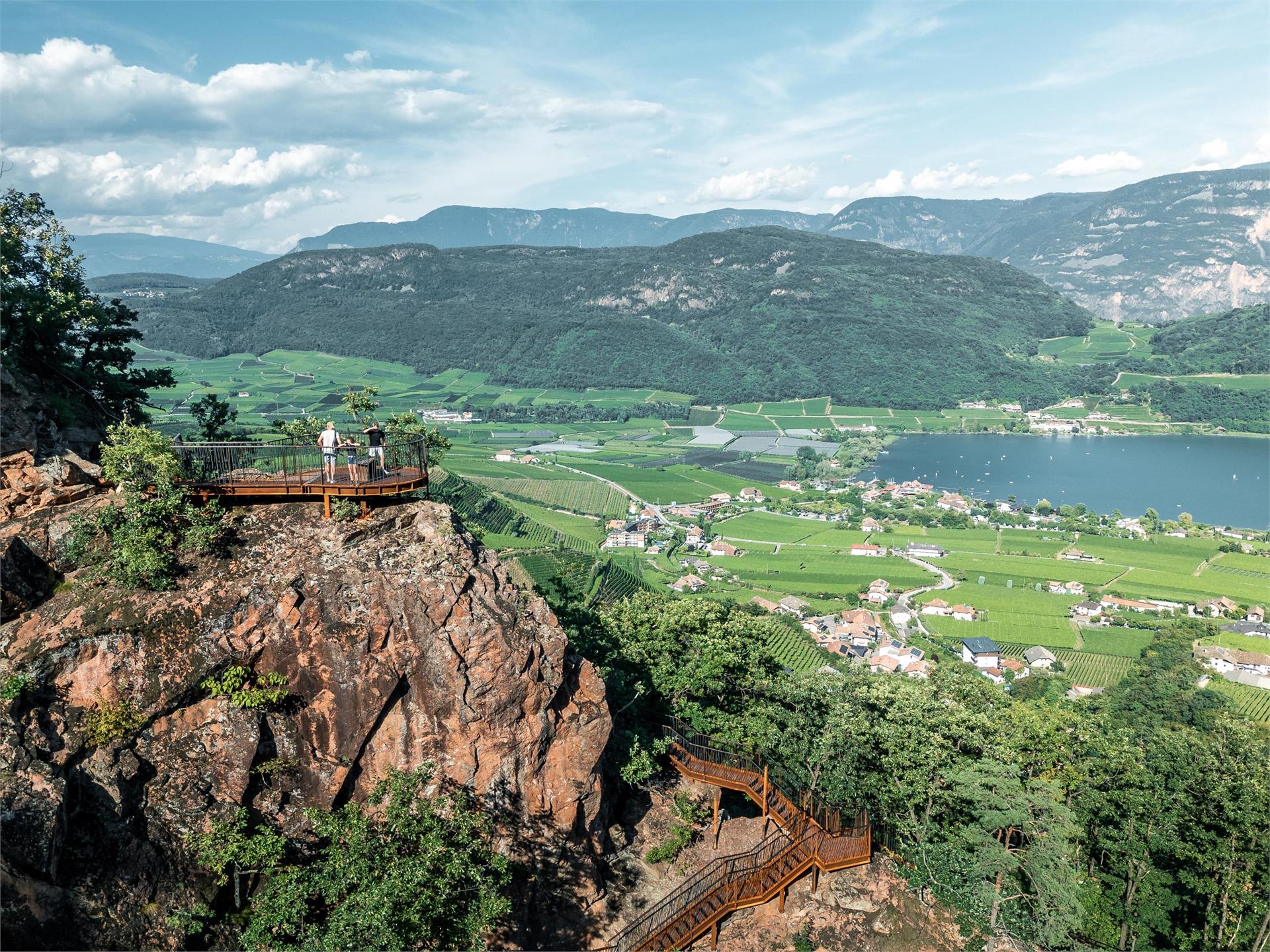
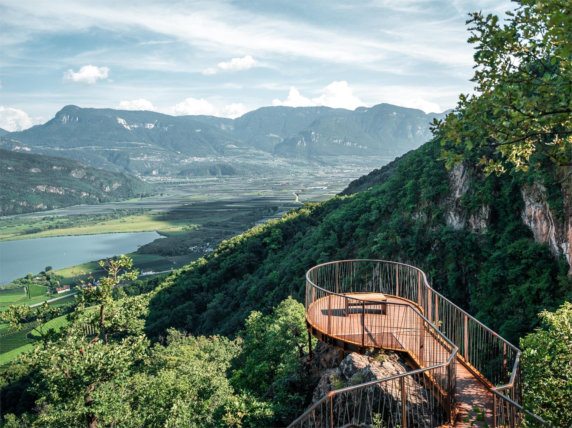
    An other version of this way would be along the Weiler „Montigl" – „Grunerhof" and then through the scottish pine wood along rock faces to a panoramic view point. From here you can already see the "Buschenschank Bergjosl" and you reach it on a firstly slight descending path then go right.

    Obtížnost: střední
    951 m nadmořská výška
    4h:50 min doba trvání
    Hiking
    Montan/Montagna - Glen/Gleno - Gschnon/Casignano - Gsteig - Montan/Montagna
    Montan/Montagna, The South Tyrolean Wine Road

    This hike goes through both the Monte Corno Natural Park, a scenic jewel rich in flora and fauna, and across the slopes of South Tyrol´s Bassa Atesina. This is where the idyllic villages of Gleno and Casignano can be found. You can enjoy a wonderful view of Castelfeder, the Adige Valley, the Mendola range of mountains and Lake Caldaro to as far away as the mountains above Merano.

    Obtížnost: nízká
    692 m nadmořská výška
    5h:00 min doba trvání
    Hiking
    Impressive mountain scenery - the Cislon Alp (1.249 m)
    Montan/Montagna, The South Tyrolean Wine Road

    This walk in the Monte Corno Natural Park provides you with the opportunity to admire unique landscapes and impressive mountain scenery. On a clear sunny day, you can make out the Palla Bianca, the Pennes Pass, the Mendola range of mountains and the Brenta Group.

    Obtížnost: střední
    750 m nadmořská výška
    5h:00 min doba trvání
    Hiking
    Überetscher walking path to Caldaro
    Eppan an der Weinstaße/Appiano sulla Strada del Vino, The South Tyrolean Wine Road

    The promenade route was built along the tracks of the former Überetsch railway and is therefore also known as the old railway embankment path. In several places there are benches and playgrounds, which invite you to linger for a while and let off steam.

    Obtížnost: nízká
    9 m nadmořská výška
    2h:22 min doba trvání
    Hiking
    Tramin to the Rastenbach gorge
    Tramin an der Weinstraße/Termeno sulla Strada del Vino, The South Tyrolean Wine Road

    From the town hall square to the fairground, Söllerstraße, after the Hotel Winzerhof turn right into a vineyard path and follow the nature trail (11+11 A) to Lake Kaltern. Turn left at the Hotel Seeleitenhof and follow the signs for "Rastenbachklamm". This is followed by a varied hike over paths, steps, platforms, bridges and past waterfalls and a stream, through the wild and romantic gorge up to Altenburg. Also worth seeing along the way are the ruins of St. Peter, just before Altenburg. Return via Altenburg, Panoramaweg and Römerweg (11) to the Söll fire station and at Hotel Plattenhof back down the nature trail to Tramin.

    Duration: 4.5 - 5 h

    Difference in altitude: 350 m (circular route)

    Obtížnost: střední
    776 m nadmořská výška
    4h:40 min doba trvání
    Hiking
    Trail e | Truden - Altrei
    The South Tyrolean Wine Road

    This route will lead you through the Truden Horn Nature Park from the multi-faceted alpine village of Truden all the way to the charming little village of Altrei. The trail is first uphill to the Krabes-Alm, at an elevation of 1,540 meters above sea-level; this is a good place to stop for a short rest. You will then proceed along a forest trail until you come to the high-altitude bog of "Langes Moos." Then you can return to Altrei via an old cobblestone path.

    Obtížnost: střední
    429 m nadmořská výška
    2h:55 min doba trvání
    Hiking
    Nature Experience Trail Tramin
    Tramin an der Weinstraße/Termeno sulla Strada del Vino, The South Tyrolean Wine Road
    Family hike featuring beautiful views of the Lake Kaltern.
    The many display boards inform interested hikers about the diverse flora and fauna and the geological discoveries of the region, making the Nature Experience Trail in Tramin a special experience for young and old.

    From the Rathausplatz (town hall square), head along Hans-Feur-Staße street, the town’s main road, till you come to the fairground where you turn left into the Mühlgasse alley. Follow thus until turning right at a junction. After crossing over a bridge, you will see the Hotel Winzerhof.
    On the curve after the Hotel Winzerhof just follow the path 11 and walk straight ahead. The trail first leads through vineyards, then heads gently upwards through mediterranean mixed forest to the restaurant Plattenhof (closed on Monday) in Sella/Söll. On the way there are some small views on the Caldaro lake. At the Hotel Plattenhof, direction Caldaro lake, turn to the left and follow path 11A for approx 20 minutes and then leave the trail and turn to the right. After 50 minutes you will be back at Tramin.
    Obtížnost: nízká
    294 m nadmořská výška
    1h:55 min doba trvání
    Hiking
    Hiking tour Valley "Frühlingstal"
    Kaltern an der Weinstraße/Caldaro sulla Strada del Vino, The South Tyrolean Wine Road

    Not difficult path with some grades. Due to the countless spring flowers this hiking tour is especially recommended in the period end of February - beginning of March. Start- and final point: historical centre of Caldaro/Kaltern. Duration of walking: about 3.5 hours. Different of altitude: about 170 meters.

    Obtížnost: nízká
    0 m nadmořská výška
    3h:30 min doba trvání
    Hiking
    A wine and walkers’ paradise: from Auer/Ora to Montan/Montagna
    Auer/Ora, The South Tyrolean Wine Road

    This walk takes you from Ora, through an idyllic wood, to the wine village of Montagna. The mountainside along which the path winds is particularly famous for the typical vineyards where the best Pinot Noir grapes in South Tyrol grow. Montagna is also the ideal starting point for the magnificent panoramic trail that has been made from the old railway line that led all the way into the Val di Fiemme.

    Obtížnost: nízká
    0 m nadmořská výška
    1h:30 min doba trvání
    Hiking
    From “Garbe” to Buchholz/Pochi di Salorno
    Kurtinig an der Weinstraße/Cortina sulla Strada del Vino, The South Tyrolean Wine Road

    With this excursion you reach the Pochi di Salorno sculpture garden. This “garden of desires” brings together the works of sculptor Tatz-Borgogno in a small deciduous wood. "Freedom and harmony amongst art and nature" is the motto that the artist has used to accompany the creation and installation of more than 200 sculptures in bronze and marble in the garden.

    Obtížnost: střední
    382 m nadmořská výška
    2h:43 min doba trvání
    Hiking
    Rotwand and Burgtallegg
    Aldein/Aldino, The South Tyrolean Wine Road
    From Auer / Ora to the viewpoints Rotwand and Burgstallegg. An unforgettable tour with many highlights, two ruins, great viewpoints, a biotope and a natural swimming lake.
    Obtížnost: vysoká
    884 m nadmořská výška
    5h:25 min doba trvání
    Hiking
    Bärental
    Kaltern an der Weinstraße/Caldaro sulla Strada del Vino, The South Tyrolean Wine Road
    Accessible from the village via the San Antonio sports area, the Bärental hiking trail is both a hiking option to Lake Kaltern and an access route to the lower part of the Rastenbach gorge. Not new, but with a new look and a new platform, this trail offers space for spending time in nature and spectacular views around the lake and the Rastenbach gorge itself. For the Bärental hiking trail, just follow the no. 13 signpost and discover the forest of Castelvecchio, the gorge, the steps and the newly constructed stairs. The new viewing platform offers an additional opportunity for a panoramic view. The only requirement for this hike is the ability to withstand heights.
    Obtížnost: střední
    322 m nadmořská výška
    2h:00 min doba trvání
    Hiking
    UNESCO-World Heritage: GEOPARC Bletterbach
    Aldein/Aldino, The South Tyrolean Wine Road
    An enticing guide!
    Take a step back in time while hiking along the GEOPARC.

    At the foot of the Weißhorn / Corno Bianco, a small streamlet dug a deep valley in the mountain over the course of millions of years, thus creating a unique natural monument: the Bletterbach gorge. Regardless of the seasonh or hour of the day, the steep rocky walls, roaring waterfalls and beautiful colours shimmering across the surfaces always show themselves under a new light, enchanting not only hikers with a penchant for geology but also nature lovers, amateur photographers and people simply looking for peace and quiet.
    Obtížnost: střední
    201 m nadmořská výška
    1h:30 min doba trvání
    Hiking
    Brenntalweg to Kurtatsch
    Tramin an der Weinstraße/Termeno sulla Strada del Vino, The South Tyrolean Wine Road
    Through the vineyards to Kurtatsch

    We hike to the wine road - junction Neumarkt/Kurtatsch and after 30 m turn left into the Brenntalweg. Follow this asphalted road for about 3 km. Continue straight on and you will see signs for the "Millastiege". We follow these and climb up through the rocks to the wine road before the village of Kurtatsch.

    For the way back we take the hiking trail Kastelaz or the less frequented panoramic road via Rungg. You will find the corresponding signs in the village of Kurtatsch.
    Obtížnost: nízká
    434 m nadmořská výška
    2h:43 min doba trvání
    Hiking
    Trail d | Gfrill - Altrei
    The South Tyrolean Wine Road

    On this segment, you will proceed first from Gfrill to the bogland lakes of the "Weiss" and the "Schwarz." From there, the route continues to the Horn-Alm, the highest point of the segment. Hikers can stop here for refreshments and then continue downhill via the Ziss Saddle – not far from there, you can admire the stunning "huckete Stoan," a free-standing erratic boulder made of porphyry the size of a house – until you come to Altrei.

    Obtížnost: střední
    467 m nadmořská výška
    3h:42 min doba trvání
    Hiking
    Trail f1 | Truden - Oberradein
    The South Tyrolean Wine Road

    This segment will take you from Truden all the way to the idyllic village of Oberradein. The trail starts out downhill as you proceed towards Kaltenbrunn (lodging options and access to public transportation). You then pass by the famed "Ice Holes" of Kaltenbrunn and steadily uphill by way of Unterradein until you come to Oberradein. This village nestled in an unspoilt alpine landscape features stunning natural beauty, with numerous hiking options.

    Obtížnost: střední
    589 m nadmořská výška
    2h:30 min doba trvání
    Hiking
    Kurtatsch/Cortaccio – Penon/Penone - Kurtatsch/Cortaccio
    Margreid an der Weinstraße/Magrè sulla Strada del Vino, The South Tyrolean Wine Road

    From the main square, we follow the initially steep Obergasse. After traveling about 100 meters - at the little square – we turn to the right. At the next junction - the fountain – we take the Maria-Hilf Gasse to the left, passing by farms and tall old poplars until it meets the road to Graun. After about 100 meters turn left on a narrow side road - marking 2 - leading to the hamlet Hofstatt (608 m). Change to the Graun road until shortly after Gasthof Halbweg where the road leads left to an asphalt road at the Himmelspfort inn – with the possibility of a detour to the village center of Penon (605 m). To return, turn right just after the restaurant at the Himmelspfort. Over a narrow path leading through vineyards, the trail climbs down and soon reaches the paved road that leads to Kurtatsch.


    Obtížnost: střední
    0 m nadmořská výška
    15h:04 min doba trvání
    Hiking
    Trail f2 | Radein - Jochgrimm - Schwarzhorn
    The South Tyrolean Wine Road

    This segment begins in Oberradein. Follow the Zirmersteig staircase uphill through the increasingly sparce high-alpine vegetation until you come to the Weisshorn (2,317 meters above sea-level). Here you can enjoy the fabulous panoramic view before embarking on the return trip down to the Jochgrimm. There are various refreshment options as well as plenty of opportunity to admire the very diverse flora of the alpine meadows. After a short breather, the segment goes up to the Schwarzhorn (2,439 m above sea-level).

    Obtížnost: vysoká
    1263 m nadmořská výška
    4h:34 min doba trvání
    Hiking
    Trail f2 | Jochgrimm - Schwarzhorn - Radein
    The South Tyrolean Wine Road

    From Jochgrimm first up to the Schwarzhorn (2,439 m above sea-level), where you are immediately rewarded with a great panoramic view. From here it goes back again to Jochgrimm and then up to the magnificent Weisshorn (2,317 meters above sea-level), once again you can enjoy a splendid panoramic view. You will then proceed through increasingly dense vegetation downhill and along the Zirmersteig staircase until you reach Oberradein, an idyllic village surrounded by verdant meadows and lush forests.

    Obtížnost: střední
    814 m nadmořská výška
    3h:52 min doba trvání
    Hiking
    Unterradein/Redagno di Sotto - Schwarzhorn/Corno Nero
    Aldein/Aldino, The South Tyrolean Wine Road
    The Weißhorn and Schwarzhorn are the two southernmost horns of the Dolomites. They are characterised by a wonderful mountain silhouette, pyramid-shaped. They belong to the local mountains of the Unterland and are known for their 360-degree distant views. Whether King Ortles, Brenta Dolomites, Lagorai Group or Schlern-Rosengarten: from here you can see them all! The Schwarzhorn is quite unjustly overshadowed by its actually "smaller brother", the Weihorn. 

    Why actually white and black? The "Trudner Line" runs through here, the geological fault line between porphyry and dolomite rock. Borders merge in this area in the tension between languages, cultures, the mediterranean south and the alpine north. A delight of enriching contrasts!
    Obtížnost: vysoká
    1246 m nadmořská výška
    6h:30 min doba trvání
    Hiking
    Walk Laghi di Monticolo
    Eppan an der Weinstaße/Appiano sulla Strada del Vino, The South Tyrolean Wine Road

    From the car park you don’t take the main road, but follow the narrow street on the right down to the hamlet Montiggl. You walk across the block of houses and go straight on. On the next intersection keep right and even before the fall turn on your left to a well signed path. Follow the pathway to the forest road on the south shore of Montiggl Lake. Keep right and follow the path around the Big Montiggl Lake until it North end. Turn right again and follow the pathway to Small Montiggl Lake (signposted). Keep right on the track around the lake until you come to an asphalt street. Only 100 meters south, then turn right and on the signposted forest road back to the car park.

    Obtížnost: nízká
    0 m nadmořská výška
    1h:30 min doba trvání
    Hiking
    A panoramic walk along the Fleims railway track
    Truden/Trodena, The South Tyrolean Wine Road

    This excursion follows the old railway line of the Val di Fiemme. This railway line was built during the First World War and between 1918 and 1936 was mainly used for freight traffic. The walk winds along the sunny slope, among lovely vineyards. This panoramic tour is particularly worthwhile for the wonderful views over the Bassa Atesina.

    Obtížnost: střední
    754 m nadmořská výška
    3h:23 min doba trvání
    Hiking
    From Radein/Redagno to Weißhorn/Corno Bianco
    Aldein/Aldino, The South Tyrolean Wine Road
    On the Weißhorn, with impressive views of the GEOPARC Bletterbach World Natural Heritage Site and the surrounding Dolomite peaks. The surroundings of the Weißhorn, the local mountain of the Unterland, are geologically extremely interesting. A blanket of white shell limestone scree (glacial deposit) characterises the picture. Botanically, the area can also hold its own.
    Obtížnost: střední
    768 m nadmořská výška
    3h:45 min doba trvání
    Hiking
    Hiking to the "Leiterburg"
    Auer/Ora, The South Tyrolean Wine Road
    Starting from theHauptplatz/Piazza Principale in Auer, through the beautiful, historic labyrinth of alleys in the direction of the waterfall. Via the "Katzenleiter" hiking path steeply uphill to the beautiful "Leiterburg".
    Once there, a fabulous view over the entire valley awaits the hikers. On this historical site you will find old wall remains and traces of the former castle.
    The way back is via the "Lahnweg".
    Obtížnost: střední
    451 m nadmořská výška
    1h:49 min doba trvání
    Hiking
    Hiking tour "Tschirglhöfe"
    Terlan/Terlano, The South Tyrolean Wine Road

    You start your hike at the church in the center of Terlan. Via the Silberleitenweg you get to Oberkreuth, where you turn right at the fountain, walk 20 m further and then take the Vorbergweg/no°4A to the left up to the Tschirglhöfe. The first path is very steep. Further up the mountain you hike past "Mugger/Zilli" and "Bergrast". You will reach the Möltner road (please pay attention to the traffic), walk downwards for approx. 150 m and turn right onto hiking trail n°4. Where the hiking trail meets the road again, you walk downwards (attention to traffic) for a short while until you turn onto the hiking trail again. After the first 20 m descent, a detour to the left to the "Wetterkreuz" is worthwhile. It is a magnificent viewpoint with the ruins of the 14th-century St.Peter miners' chapel below. The path now leads steeply down to the "Klaus in der Mühl" farm and then leads into Kirchgasse, through which you return to the starting point.

    There is no rest stop on this hike.

    Obtížnost: střední
    452 m nadmořská výška
    2h:17 min doba trvání
    Hiking
    Trail f | Truden - Schwarzhorn - Jochgrimm
    The South Tyrolean Wine Road

    This challenging hike from Truden via the Schwarzhorn and all the way to the Jochgrimm is a unique adventure. From Truden, you'll first proceed uphill to Kaltenbrunn (refreshment stop and access to public transportation). From here, you can then proceed to the famous "Ice Holes" – an unusual phenomenon where cold air streams out of holes in the ground even on the hottest days of summer. You will then proceed steadily uphill via the challenging "Leitensteig" staircase until you come to the Kugeljoch; from this pass, you have a magnificent panoramic view of the Fleims Valley. From the Kugeljoch, you will continue to the Schwarzhorn (2,439 meters above sea-level). Finally, you follow the descending path to the Jochgrimm, the goal of this tour. This hike offers a wealth of unique natural beauty and is – in spite of the level of difficulty – an absolute "must" for ambitious hikers.

    Obtížnost: vysoká
    1716 m nadmořská výška
    6h:05 min doba trvání
    1 2 3 4 5